
Destinations
The Complete Spiti Valley Circuit: Manali to Kaza to Kalpa by 4x4
The full Spiti loop in one guide - the route, the best months, and every fuel and water stop from Manali to Kalpa.
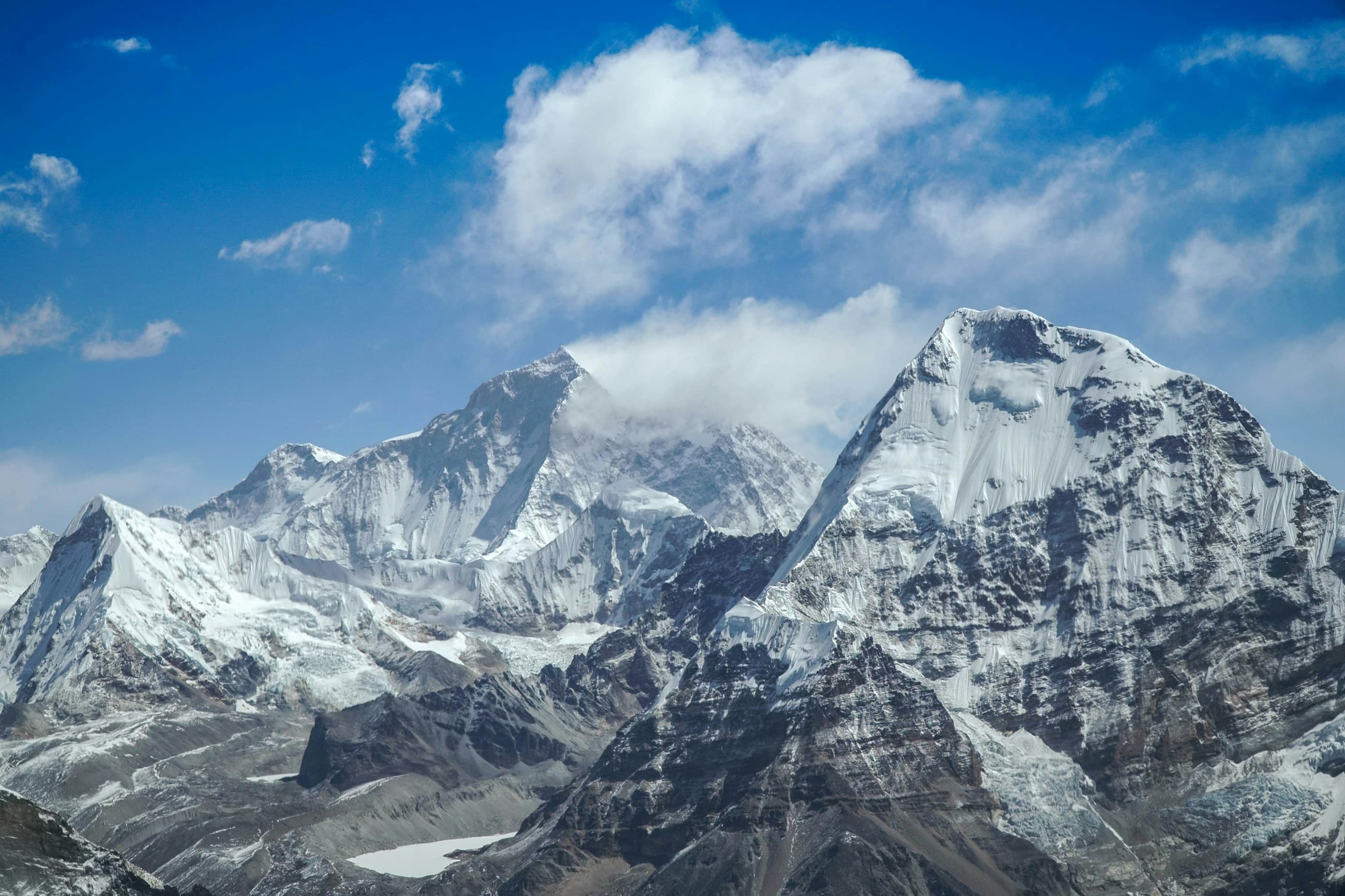
The classic Spiti Valley circuit runs Manali to Kaza to Kalpa over roughly 9 to 11 days and about 850 km, climbing over Kunzum La at 4,551 m before dropping into the cold desert. The single most important rule is direction and acclimatisation: enter from Shimla and Kinnaur so you gain altitude slowly over four days, and exit over the high Manali side. Do it the other way and you go from Manali at 2,050 m to Kunzum La at 4,551 m in one morning, and altitude sickness will end your trip before it starts. We have run this loop more than 30 times in Thars, Gurkhas and a Hilux, and the order below is the one that keeps people healthy and the vehicle intact.
What is the best route for the Spiti circuit?
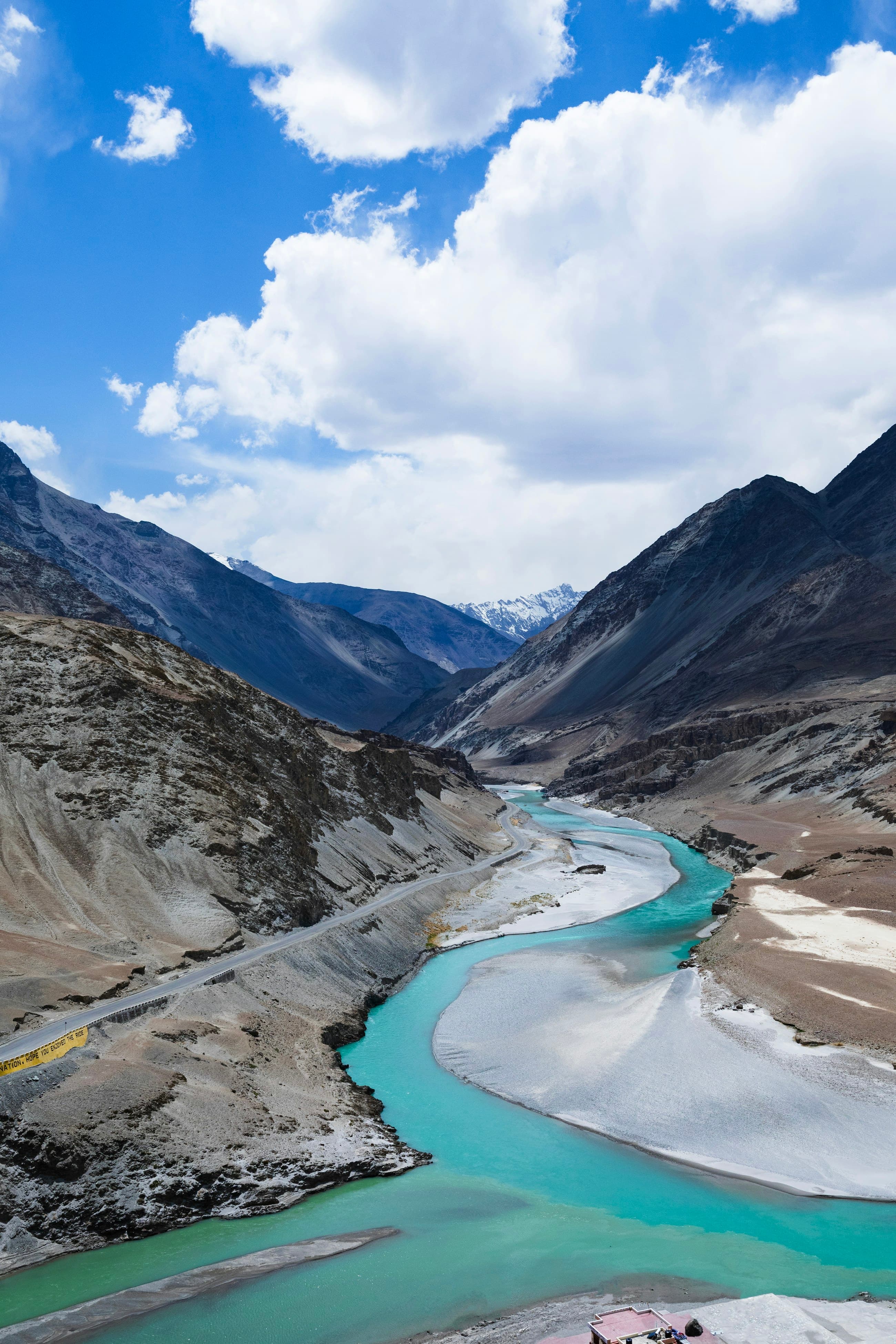
Drive it anti-clockwise as a loop. Day 1 to 2: Shimla to Sangla or Chitkul in the Sangla valley (Chitkul at 3,450 m is the last village before the Tibet border). Day 3: Chitkul to Kalpa, sleeping under Kinner Kailash. Day 4: Kalpa to Nako via Khab, where the Spiti and Sutlej rivers meet, then to Tabo at 3,280 m, home to a 1,000-year-old monastery. Day 5 to 7: Tabo to Kaza, the headquarters town at 3,800 m, using it as a base for Key Monastery, Kibber, Langza, Komic and Hikkim. Day 8: Kaza to Chandratal via Kunzum La. Day 9: Chandratal to Manali over Rohtang or the Atal Tunnel. This sequence is roughly 750 to 850 km depending on side trips and gives your body a full four days below 3,500 m before the big passes.
The reason this order works is altitude arithmetic, not scenery preference. From Shimla at about 2,200 m you sleep at Chitkul (3,450 m), then Kalpa (around 2,960 m), then Tabo (3,280 m), then Kaza (3,800 m) - a staircase where no single night jumps your sleeping altitude by more than roughly 500 to 600 m, which is exactly what your lungs can tolerate. Reverse it and you would sleep at Manali (2,050 m) and be standing on Kunzum La at 4,551 m before lunch the next day, a 2,500 m gain that routinely lays people out. The day distances are deliberately short - 100 to 160 km on average - because Spiti roads are slow. A 150 km day on the broken stretch past Nako can take six or seven hours with photo stops and a landslide clearance, so do not let the modest map distances fool you into planning long days.
When should you go to Spiti?
The full loop, including the Kunzum La and Chandratal section, is only open from roughly mid-June to early October. Kunzum La is snowbound and shut the rest of the year. If you want the complete circuit, mid-June to late September is your window, with July and August being the most reliable for the high passes despite some monsoon landslides on the Kinnaur side. The Kinnaur half (Shimla to Kaza via Kalpa and Tabo) stays open all winter because it never crosses Kunzum La, so a winter Spiti trip is possible - but it becomes an out-and-back from the Shimla side, not a loop, and Kaza drops to -20C with the Chandratal road firmly closed.
- Mid-June to September: full loop open, both high passes drivable, the only time for Chandratal.
- October: Kinnaur side still good and stunningly clear, but Kunzum La can close after the first snow without warning.
- November to April: Kinnaur side only, deep winter, -20C nights at Kaza, frozen waterfalls, no Chandratal.
- Avoid peak monsoon flash points: the stretch between Rampur and Spillow on the Kinnaur road is the most landslide-prone in July.
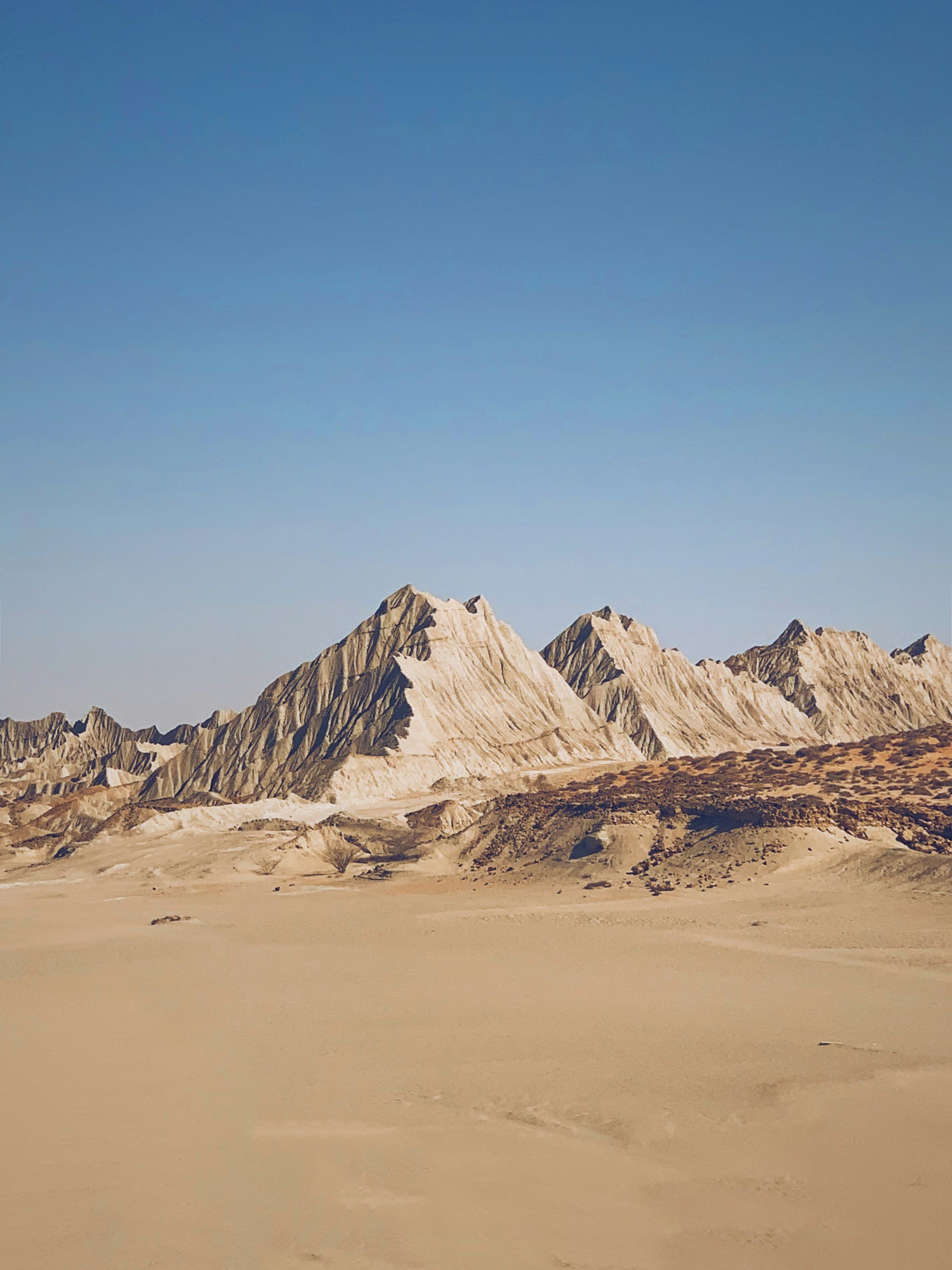
Winter Spiti is its own expedition and we run it as the Spiti Frozen trip rather than the summer loop. From late December the Kinnaur road to Kaza stays open but turns to packed snow and black ice above Nako, daytime highs sit below freezing, and the night drops to -20C or colder. This is where snow chains stop being optional - we fit TractionX AX chains to the drive axle for the icy climbs and carry the heavier MX set for the worst sections, because a stock all-terrain on glare ice simply slides. A winter trip also means shorter daylight, so you plan to be off the exposed stretches well before dark, and you carry a ThermaEvo heater because a homestay in Kaza in January is genuinely arctic at night. The frozen waterfalls and the empty, blue-white valley are worth it, but only with cold-rated gear and chains on board.
Where do you refuel and get water?
Fuel discipline is what separates a relaxed Spiti trip from a stranded one. After Rampur, your reliable pumps are Powari (near Reckong Peo) and then Kaza - and between them lies the single longest fuel gap on the circuit, about 190 km through Nako and Tabo with no dependable diesel. Top up completely at Powari, carry 20 litres in a jerry can, and fill again the moment you reach Kaza. From Kaza to Manali is another 200 km plus with the Tandi pump (near Keylong) being the next certain fill - the old overlander mantra Tandi to Kaza, fill your tank still holds. For water, the tap water in Tabo, Kaza and Kalpa is glacier-fed and safe boiled or filtered; we run a HydroX26 tank topped up at Kaza and treat everything, because stomach trouble at 4,000 m is genuinely dangerous.
Worth knowing: the Kaza pump is a single retail outlet and it does run dry, especially in peak season when demand spikes and the supply tanker is delayed by a landslide on the Kinnaur road. Treat a successful fill at Kaza as luck, not a guarantee, which is exactly why the jerry can matters even though it feels like overkill on a tarred road. The same applies to the Kaza-to-Manali leg: between Kaza and the Tandi pump there is genuinely nothing, and the climb over Kunzum La plus the low-gear crawl to Chandratal burns more than the distance suggests. We always leave Kaza with a full tank and a full can for that leg and have never regretted the few extra kilos.
How should you set up camp on the circuit?
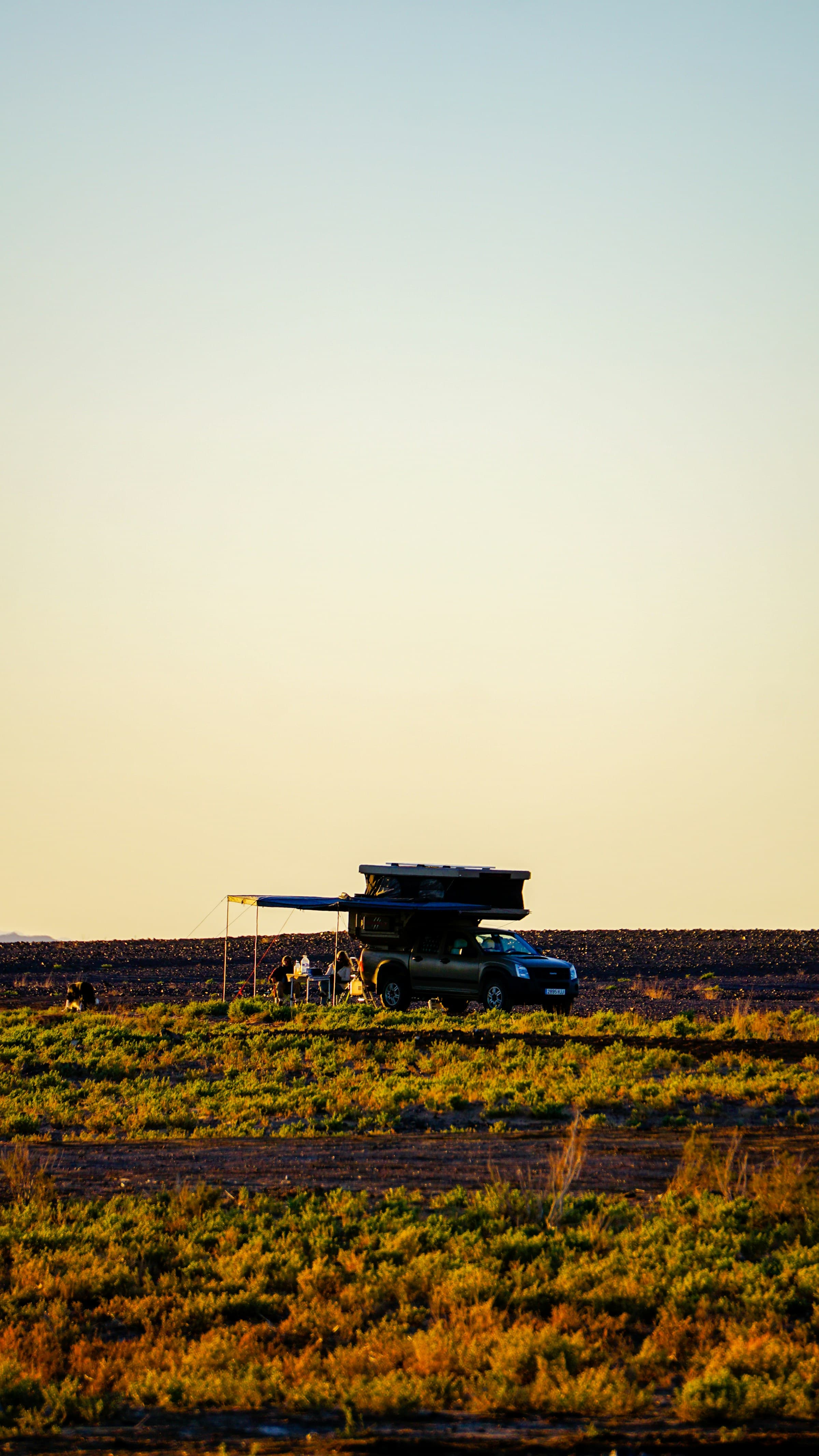
Most nights you will sleep in homestays in Kalpa, Tabo, Kaza and Kibber, which is the right call for acclimatisation and for supporting these villages. The one night that rewards a rooftop tent is Chandratal, where camping is restricted to designated sites about 2 to 3 km from the lake itself (no pitching on the shoreline, by order of the administration). At 4,300 m the wind comes off the lake hard after sunset, so park nose into the wind and deploy the shell low. A hardshell tent like the Bison61 handles the gusts far better than anything ground-pitched in that bowl. Expect water in your bottles to skin over with ice by 2 am even in August.
There is a real acclimatisation reason to favour homestays for most nights and save the tent for Chandratal. Sleeping inside a heated village house at Kaza (3,800 m) is kinder on a body still adjusting than camping at the same height, and it spreads your money to the families who keep these villages alive. Chandratal is the exception worth the rooftop tent because the designated camping zone is a genuinely beautiful, exposed bowl and there is no homestay at the lake. When you do pitch there, the drill is simple: arrive with daylight to spare, point the vehicle nose-first into the wind that funnels off the lake at dusk, deploy the shell low to cut its wind profile, and run a four-season bag because the temperature collapses the moment the sun drops behind the ridge. A SaberLight 270 awning gives you a sheltered cooking spot out of that wind, which matters when you are trying to brew tea at 4,300 m with numb fingers.
Spiti does not punish bad drivers, it punishes impatient ones. Gain your altitude slowly, fill your tank at every pump, and the valley lets you in.
What should you carry for the high passes?
The river crossings below Kunzum La and the slush near Chandratal are where stock vehicles get stuck. Carry recovery boards, a snatch rope and rated shackles, and a tyre compressor so you can air down to 18 to 20 psi for the loose moraine and re-inflate for tarmac. A working spare and a plug kit are non-negotiable because the nearest tyre shop to Kaza is in Reckong Peo, hours away. For altitude, carry Diamox (after talking to your doctor), a pulse oximeter, and know that anyone whose oxygen saturation sits below 80 percent and who is confused or breathless must descend - the road back down to Tabo at 3,280 m is your medicine.
The water crossings deserve a word on technique, because they catch out drivers who treat them like a charge. The nalas below Kunzum La and on the Chandratal track are glacier-fed, so they are lowest in the cool of early morning and swell through the afternoon as the sun works on the ice upstream - cross early, ideally before 10 am. Walk the crossing first if you can, pick the shallowest line, engage low range, and drive through at a steady walking pace that pushes a gentle bow wave ahead of the bumper without swamping the engine bay. Do not stop mid-stream and do not gun it. If a crossing looks above the wheel centres or the current is shifting rocks, wait - an hour earlier in the day it will often be half the depth. Air down to 18 to 20 psi for the loose moraine on either side, which is where vehicles actually bog down, and air back up before you return to tarmac.
- Recovery kit: boards, snatch rope, shackles, compressor, full-size spare and plug kit.
- Altitude kit: pulse oximeter, Diamox on doctor's advice, the discipline to descend if saturation drops.
- Cold kit: a four-season sleeping bag rated to -10C for the Chandratal night, even in summer.
- Cash: ATMs in Spiti are unreliable and frequently empty, so carry enough cash for the whole loop from Reckong Peo or Manali.
- Tyres: 235/70 R16 or 265/65 R17 all-terrains air down well for the moraine; carry a plug kit because sidewall cuts from sharp moraine are common.
Frequently Asked Questions
How many days do you need for the Spiti circuit?
Plan 9 to 11 days for the full Manali to Kaza to Kalpa loop done safely. You can rush it in 7, but that means skipping acclimatisation days and risking altitude sickness. Adding the Pin Valley or extra days at Kaza pushes a comfortable trip to 12 days.
Do you need a permit for Spiti Valley?
Indian citizens do not need a permit for the main Spiti circuit including Kaza, Tabo and Chandratal. Foreign nationals need an Inner Line Permit for the stretch between Sumdo and the Kinnaur border, obtainable in Reckong Peo or Kaza. Always carry original ID and several photocopies.
Can a normal car do the Spiti circuit or do you need a 4x4?
Hatchbacks reach Kaza on the tarred Kinnaur road in good weather, but a high-clearance 4x4 is strongly advised for the water crossings near Kunzum La and the rough Chandratal track. After rain or early snow, a 4x4 stops being optional.
Is the Spiti circuit safe to self-drive?
Yes, for a confident mountain driver with a sound vehicle and the right acclimatisation plan. The dangers are altitude, fuel range and weather, not the difficulty of the driving itself. Never drive the exposed sections after dark, and always tell someone your day's plan.
Can you drive the Spiti circuit in winter?
Only the Kinnaur half. From November to April Kunzum La is shut, so winter Spiti becomes an out-and-back from Shimla to Kaza via Kalpa and Tabo rather than a loop, with no access to Chandratal. Nights at Kaza fall to -20C, the road turns to ice above Nako, and snow chains plus cold-rated sleeping gear and a heater are essential.
Put it into practice
Headed this way? We run guided expeditions on these routes - permits, recovery and a mechanic all handled.